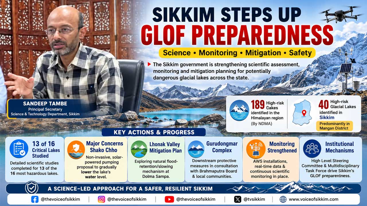
According to Tambe, the National Disaster Management Authority (NDMA) has identified 189 high-risk glacial lakes across the Himalayan region, of which 40 are located in Sikkim, predominantly in Mangan district.
Gangtok, Sep 2: The Sikkim government has intensified scientific assessment, monitoring and mitigation planning for potentially dangerous glacial lakes, with 40 high-risk lakes identified across the state and detailed studies completed for 13 of the 16 lakes considered among the most critical.
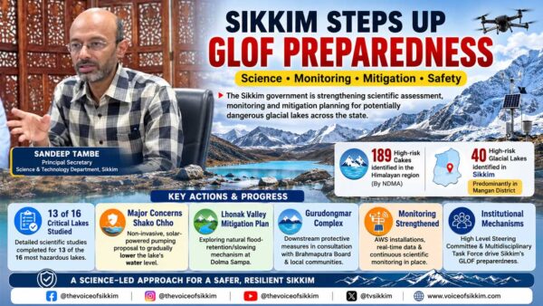
Principal Secretary of the Science and Technology Department, Sandeep Tambe, outlined the state’s progress in tackling Glacial Lake Outburst Flood (GLOF) risks, describing the emerging glacial hazard as a growing challenge linked to climate change.
According to Tambe, the National Disaster Management Authority (NDMA) has identified 189 high-risk glacial lakes across the Himalayan region, of which 40 are located in Sikkim, predominantly in Mangan district.
Many of these lakes are situated at altitudes of around 17,000 feet, making scientific assessment extremely challenging and requiring specialised high-altitude expeditions.
13 of 16 Critical Lakes Studied
Tambe said five major high-altitude scientific expeditions have been organised over the past two years.
The multidisciplinary teams included experts and officials from the Sikkim State Disaster Management Authority (SSDMA), Science and Technology Department, Mines and Geology Department, Forest Department, Central Water Commission (CWC), Geological Survey of India (GSI), Sikkim University and other agencies.
Of the 16 lakes identified as being among the most hazardous, detailed scientific studies have so far been completed for 13.
The studies go far beyond visually inspecting the lakes. Scientists measure the volume and depth of water using specialised unmanned equipment, assess the geological strength of terminal moraines holding back the lakes and examine whether ice, hard rock or softer material exists underneath.
Teams also study seepage through moraine dams and the possibility of avalanches, landslides or other mass movements entering the lakes and triggering dangerous displacement of water.
Some of Sikkim’s largest glacial lakes contain tens of millions of cubic metres of water, highlighting the potential scale of the hazard in the event of a sudden breach.
The multidisciplinary scientific work has also received international academic recognition, with related research published in the journal Natural Hazards.
Shako Chho Among Major Concerns
One of the most significant concerns identified by the government is Shako Chho, a high-risk glacial lake situated above the Thangu region.
Tambe said the lake is particularly concerning because it does not have a conventional natural outlet. Instead, water is believed to be percolating through its terminal moraine.
Seasonal changes in the lake’s water level indicate movement of water through the moraine itself, raising concerns about the long-term stability of the natural barrier.
The lake contains approximately 27 million cubic metres of water.
In the event of a breach, water from the lake could flow directly towards Thangu, posing a potential threat to civilian settlements as well as defence establishments in the region.
Experts have therefore advised against physically disturbing the fragile terminal moraine.
Instead, the state is pursuing a non-invasive mitigation proposal to gradually lower the lake’s water level through solar-powered pumping.
The Detailed Project Report for the proposal has been submitted to SSDMA and forwarded to NDMA for consideration.
Implementing the project at around 17,000 feet, however, presents major technological and environmental challenges. There is no conventional electricity supply or mobile connectivity at the site, while freezing winter temperatures and the fragile high-altitude ecosystem also have to be taken into account.
Lhonak Valley Mitigation Plan Under Study
The government is simultaneously exploring a different approach for the Lhonak complex, which includes the South Lhonak and North Lhonak areas.
South Lhonak Lake was associated with the catastrophic October 2023 GLOF that caused widespread destruction downstream.
According to Tambe, direct engineering intervention near the lake is difficult because of the extremely fragile terrain and lack of road connectivity. Reaching the area itself requires an arduous trek.
Scientific teams studying the valley, however, identified an important natural feature at Dolma Sampa near Muguthang, approximately 24 kilometres downstream from the lake.
The valley, which is considerably narrower upstream, expands to roughly one kilometre in width around Dolma Sampa and remains broad for approximately three kilometres, creating a large flat area.
During the 2023 GLOF, this terrain appears to have acted as a natural slowing zone, allowing floodwaters to spread while boulders, sediment and debris were deposited.
Scientists are now examining whether this natural feature could be supplemented to further slow or retain a future GLOF before it travels downstream.
Tambe stressed that extensive feasibility and scientific studies are required before any structure is constructed because an inappropriate intervention could potentially worsen rather than reduce the hazard.
The Central Water Commission, under the Ministry of Jal Shakti, has joined the scientific assessment of the Lhonak Valley, and the mitigation concept remains under development.
Gurudongmar Complex Also Being Assessed
A third major mitigation proposal concerns the Gurudongmar Lake area.
While Gurudongmar itself may appear calm, scientists are concerned about large and relatively young glacial lakes situated higher in the landscape.
Some of these lakes have reportedly formed over the past few decades and remain connected to glaciers, making the wider lake system important from a hazard perspective.
Scientists are therefore studying the lakes as an interconnected complex rather than considering Gurudongmar in isolation.
The state is working with the Brahmaputra Board, under the Ministry of Jal Shakti, to develop a mitigation strategy.
Officials are also consulting local communities while examining measures that could be undertaken downstream without disturbing Gurudongmar Lake itself, given its immense religious, cultural and ecological significance.
Monitoring Systems Strengthened
Alongside physical mitigation planning, Sikkim has strengthened real-time and near-real-time monitoring of vulnerable glacial environments.
Monitoring installations at important locations are helping authorities obtain weather observations, water-level information and photographic data.
Recent expeditions have also included installation of Automatic Weather Stations near the Gurudongmar area and at Dolma Sampa, strengthening the scientific data network in the high-altitude region.
South Lhonak is presently reported to be stable, although authorities continue monitoring the lake and surrounding glacial environment.
Climate Change Creates New Himalayan Challenge
Tambe described glacial hazards as an emerging challenge that requires a combination of science, engineering, disaster preparedness and continuous monitoring.
Unlike conventional infrastructure projects, interventions at glacial lakes must be designed for extreme elevations, inaccessible terrain, fragile ecosystems and rapidly changing climatic and geological conditions.
The government has constituted institutional mechanisms including a High Level Steering Committee and Multidisciplinary Task Force, with the Science and Technology Department playing a key role in coordinating scientific assessment.
With detailed studies of 13 critical lakes already completed, authorities are now moving towards developing lake-specific mitigation measures rather than adopting a single approach for every location.
The emerging strategy includes non-invasive water-level reduction at Shako Chho, investigation of a possible flood-retention or slowing mechanism in the Lhonak Valley, and downstream protective measures for the Gurudongmar complex.
The initiatives mark an effort to move Sikkim’s GLOF management from hazard identification towards continuous monitoring, scientific forecasting and site-specific mitigation following the devastating lessons of the October 2023 South Lhonak disaster.